- Home
- Electronics & Instrumentation
- Marine Gps Chartplotter
Do You Really Need a
Marine GPS Chartplotter?
As the name might suggest, a marine gps chartplotter is a marriage of electronic chart software and GPS technology combined in a single display.
Marine chart plotters come either in the form of a software package installed on a laptop computer, or a dedicated instrument. Each has its merits, and both rely on an interface with a GPS signal.
The screen is normally larger on a laptop, but some will argue that its vulnerability as a portable device makes it less attractive than a dedicated plotter, most of which are marinised and fully weatherproof.
But if you already have a laptop and want to save a few bucks, then the laptop route may well be the way to go - particularly so now that fully functional free chart plotter software can be readily downloaded from the internet - but you won't get the same extensive functionality as you'd get from a bespoke unit.
A Marine GPS Chartplotter - Luxury or Necessity?
I failed to get excited by marine GPS chartplotters for a long time, preferring paper charts that filled the entire surface of my chart table rather one which only filled a small screen - if I'd thought about it a little longer, perhaps I'd have realised they weren't mutually exclusive.
But while reviewing the options for a new radar installation at the London Boat Show, I was persuaded to play around with a multi-function display unit on a manufacturer's stand.
Not only was it possible to switch between the radar display and the chart plotter display, you could also view them simultaneously in 'split-screen' mode. But what did it for me was the overlay mode.
This enabled the radar display to overlay the chart display, with zooming in and out making it much easier to interpret when close to shore. I didn't stand a chance - it had to be mine.
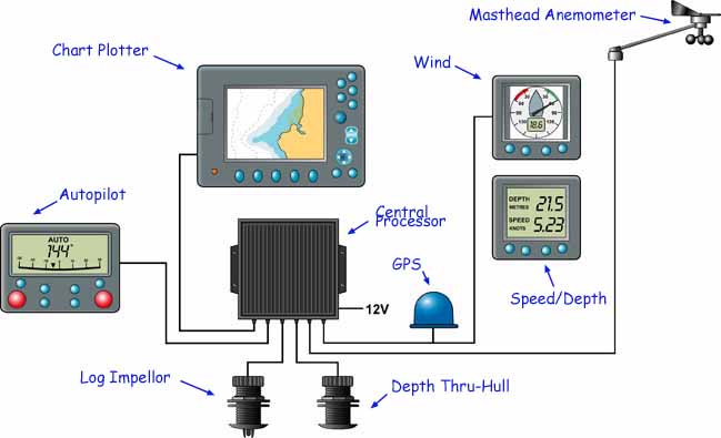
Installed at the chart table and fully integrated with wind, log and depth instruments it's become a very useful aid to both navigation and passage planning aboard Alacazam and supplements - not replaces - my paper charts.
Mine is just a few years old, but already it's outdated. Current models of multi-function chartplotters include sonar, depth and fish-finder displays...
With my intended route shown on screen, and Alacazam's position marked by an icon, a deal of valuable information is shown graphically. For instance:~
- The true (or relative) wind strength and direction is shown as a vector arrow at the icon, and similarly another arrow shows the combined effect of set and drift;
- A track line shows where we've been. If this is parallel to the desired course and not to windward of it, we're doing OK. If it's diverging from the desired course and we can't sail any closer to the wind, then we'll need to tack at some stage, and it's often clear to see when this will best be done.
Recently I've linked an AIS (Automated Identification System) to my marine GPS chartplotter which further increases its functionality.
So is a marine chartplotter a luxury or a necessity?
It's definitely a luxury, but a very attractive one - I wouldn't want to be without a chart plotter now.
You might like to take a look at these...
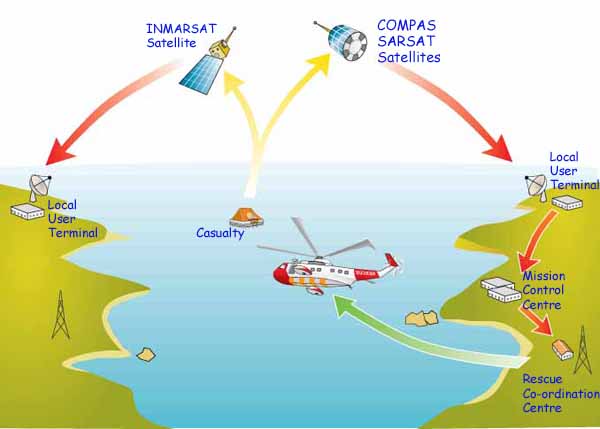
The GMDSS System; What Is It and What Does It Do?
Were it not for the GMDSS System we sailors would have no DSC, SATCOM, MSI, NAVTEX, EPIRB or SART Systems. If that leaves you none the wiser, read on
Is Small Boat Radar Right for Your Sailboat?
Expensive and power thirsty though small boat radar might be, there are times when you wouldn't really want to be without one. Here's what we found
Which Type of Sailboat Autopilot is Right for Your Boat?
If your boat's batteries can keep up with electrical appetite of a sailboat autopilot, one of these devices can make an attractive alternative to windvane self steering.
The Marine GPS System Can Do A Lot More Than Position Fixing
The versatile marine GPS system provides identical functionality for both handheld marine GPS units and fixed GPS units. So which is best for your boat?
Recent Articles
-
Wauquiez Gladiateur 33 for Sale
Apr 10, 24 05:40 AM
'Kesh', my Wauquiez Gladiateur 33 is only for sale because we've decided to go for a larger sailboat. She currently berthed in Florida, USA. -
'Cabo Frio', a Catalina Morgan 43 for sale
Apr 01, 24 08:35 AM
This Catalina Morgan 43 is for sale at a very reasonable price. She offers up to 7 berths in 2 cabins + saloon. There is full 6'5" standing headroom and good ventilation throughout. -
Live Aboard Boats For Sale
Mar 30, 24 07:02 PM
Ready to live the dream? Then browsing through this listing of live aboard boats for sale might just get you on your way...

Our eBooks...

A few of our Most Popular Pages...


Copyright © 2024 Dick McClary Sailboat-Cruising.com