- Home
- Sailing Authors & Their Writings
- Dr Michael Cohen
- Navigation
Navigation
It's Not Just for the Birds!
by Dr Michael Martin Cohen, M.D.
This is dedicated to Professor Marvin Creamer who died August 12, 2020 at the age of 104. He remains the only person to circumnavigate the globe without the use of any navigational instruments: no GPS, electronics, radio, compass, sextant, and not even a wristwatch.
His circumnavigation lasted from 21 December 1982 to 17 May 1984. He stands alone as a testament to what Tristan Gooley has called “Natural Navigation” which is the art of finding your way through the world using clues from nature. A natural navigator learns how to read the stars, sun, moon, wind, water, land, animals, and plants.
Creamer as a child became enamored of the peoples who could navigate long distances over land or water and find their way home. We have discussed in Chapter 2 of Healthy Boating & Sailing the Vikings, Inuit, and the Polynesian navigators but there are other examples from the past.1
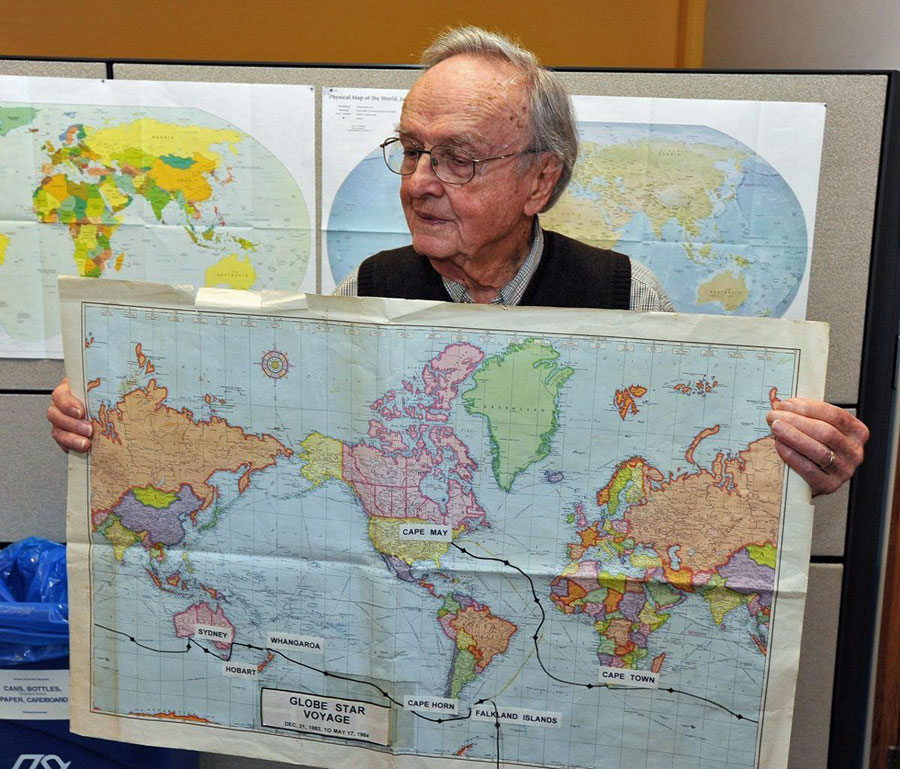 Figure 1: Marvin Creamer in 2013 discussing his journey
Creamer realized that these natural navigators took advantage of every clue that was available to them. And so, he became knowledgeable about everything that could provide information about where he was in the world. You can get some idea from this description of his rounding of the Horn (from a New York Times obituary).2
On Dec. 13, a day of no visibility, the crew rounded Cape Horn without being sure that they had done so. The next day’s entry in the ship’s log offers a masterly demonstration of how they worked out the fact:
“It is believed that we rounded the Horn at noon yesterday and have amended our longitude accordingly. We were not able to sight any landmarks so have based our conclusion on
1) the presence of an extremely cold north wind of relatively short duration, and
2) the change of water color from blue to a fairly dark, transparent green to a lighter, less transparent green and back to a quite dark transparent green as we proceeded from west to east at an estimated latitude of 56°55’.”
On [another] occasion they sat, becalmed, bothered and bewildered, until his geographer’s ears came to their aid. As the wind started up again, a crew member happened to open a hatch. It emitted a loud squeak. That sound told Professor Creamer unequivocally in which direction the boat was facing: Only dry air from the Antarctic, he knew, would have caused it. Moist air from the opposite direction would have lubricated the hatch, yielding a more congenial noise.
So, if you think about it, what Creamer has accomplished is due to his absolute mastery of all of the sensory inputs to his nervous system: vision, temperature, sound, smell etc. He was not totally dependent on only one input; so if it is overcast for days at a time he can utilize the wind direction and the ocean swells, and the color of the water, etc.
We are stubbornly visual creatures for the most part, (unless as Professor Creamer we studiously train ourselves to play close attention to all of our other senses). We are always looking for visual landmarks from which to obtain a fix. But what do we do if there are no visible landmarks and we are at sea?
Dead Reckoning a.k.a. Path Integration
 Figure 2: The Walking Dead “Dead Reckoning”
OK, let’s get two things straight. The “Dead” in dead reckoning has nothing to do with the Walking Dead. It is an old nautical term. And navigation is not just for sailors and pilots. Navigation is a key to life on earth – at least for all animals that we know of – we navigate for food, for fun, to flee, and to… find a mate. We navigate through building complexes (and sometimes lose our way) and we navigate to the bathroom at night. We take our navigation skills for granted until we lose them. One of the earliest signs of Alzheimer’s disease is getting lost, while walking or driving in one’s own neighborhood or even walking to the store. Wandering is a real danger in patients with dementia, (more on that below). And there is even a developmental disorder called Developmental Topographical Disorientation (DTD) which refers to the lifelong inability to orient in extremely familiar surroundings despite the absence of any acquired brain damage or neurological disorder. These are people who can get lost in their own neighborhood. And no, your wife or husband probably does not have it – as it is rare.
At the other extreme are the Polynesian, Inuit, and Aborigines “navigators” discussed in Chapter 2 of Healthy Boating & Sailing. And of course, Professor Creamer. They all used every navigation system available and switched between them as needed. But as I mentioned, we are visual creatures and so we are always looking for environmental cues or landmarks to tell us where we are. What about those times at sea (or a pilot under visual flight rules) when the sky is overcast and there are no environmental cues?
In that situation we are dependent on dead reckoning (DR) until there is the opportunity to get a “fix.”
Before the advent of modern electronic navigational aids such as GPS, offshore and ocean navigation depended on dead reckoning (DR). For example, the Vikings who often used “natural navigation” did sometimes take to the open seas and when they did, they practiced DR. Likewise the Polynesians when they did not have a star to steer by or some other environmental cue like an expected ocean swell. (Figure 3)
DR is one of the oldest methods of navigation. It is the process by which a current position is calculated based upon a prior known position and a vector representing both direction and an estimate of the distance. The angle is from your compass and the distance is either provided by the electronics or estimated based upon speed and time elapsed. DR is necessary when there are no visible landmarks which can be used to confirm your position (obtain a “fix”).
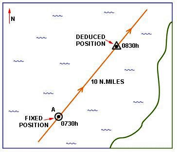 Figure 3: Dead Reckoning (DR) from fixed position to deduced position
As you add vectors, representing changes in course, (Figure 4) errors begin to accumulate and the deduced position becomes less and less certain until, hopefully, you can obtain a fix (Figure 5) and correct your position.
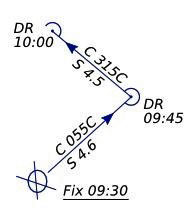 Figure 4: DR after change of course C=course S=speed
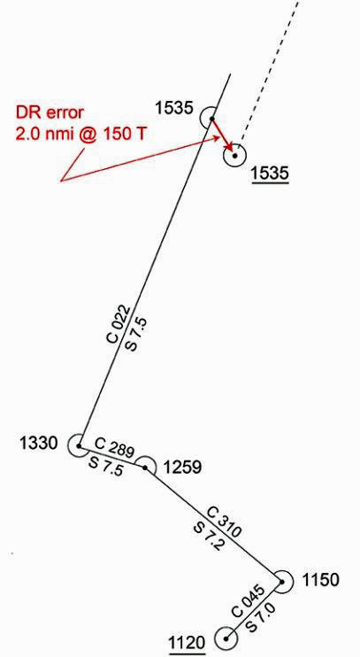 Figure 5: DR with ultimate error correction with new fix
Many animals -- as well as humans who are dedicated to natural navigation -- practice DR although when animals perform it, DR is referred to as Path Integration. The main difference is that although human navigators are interested in getting from the Start position to a destination (see Current Position below), most other species are also interested in going directly back home! (see Integrated Path below). Often our return journey is a separate issue, but not always.
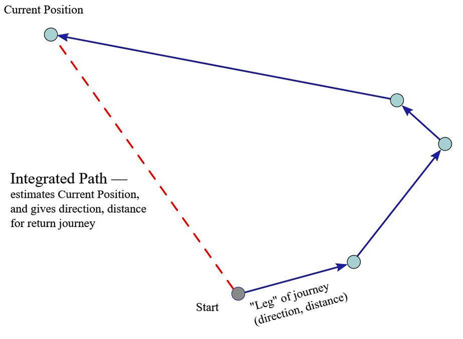 Figure 6 Path Integration – note the return journey
How species are able to integrate these vectors in their tiny little brains is not yet clear. They are able to not only estimate their current position but also to integrate the vectors into a path for the return journey. (Figure 6)
Before we go any further, we need to reconsider the sensory inputs to the system for humans. Sensory inputs from the environment – landmarks, celestial cues from the sun, are referred to as allothetic or external cues. On the other hand, both humans and most other species also depend on internal or idiothetic cues. These cues are due to self-motion. These idiothetic cues are absolutely critical when in an environment without landmarks. In other words when you are on your own – as in the ocean, in a plane, or in a desert – you are hopefully paying attention to these internal idiothetic cues. “Go ahead and take your eyes off the Electronic Chart Display and Information System – the battery is dead, man – so pay attention to your own body!”
In humans there are three main sources:
- inner ear motion detector (vestibular)
- visual motion detector (optic flow)
- intrinsic motor feedback odometer
The inner ear motion detector was discussed at length in the first chapter of Healthy Boating & Sailing. The vestibular system includes the semicircular canals which measure rotational movement of the head and the otolith organs which measure acceleration. As we move forward or backwards or as we rotate, the vestibular system measures the movement and the brain keeps track of it. [See Chapter One of Healthy Boating & Sailing for a much more detailed discussion of this system.]
The second system is vision, so-called optic flow:
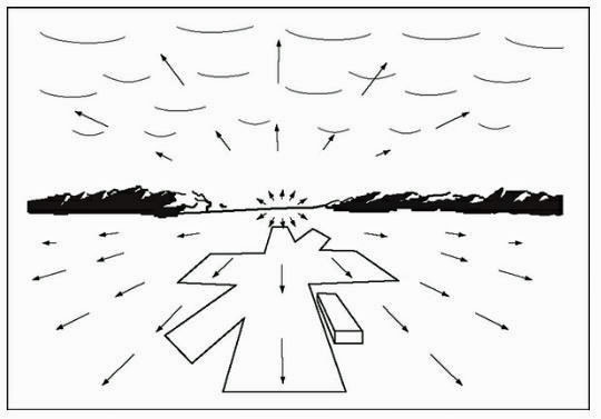 Figure 7: Optic Flow3
Optic flow is movement of the visual scene interpreted as self-motion. That is, as one moves through the world, visual flow is the sensation of movement in the opposite direction to which one is moving (Figure 7). As one moves forward the optic flow is moving from front to back. Optic flow collaborates with the vestibular system to keep track of our movement through the world. [Optic flow is also responsible for that phenomenon of perceived movement which all of us have experienced, when two trains are sitting side by side in a station. As the other train moves away, there is the illusion that your train is moving. That illusion that briefly feels so real is due to optic flow.]
But there is a third system to keep track of our movement – and that is the motor system itself which monitors the movements we actually make. Suppose that you were blindfolded and taken along a route with a few twists and turns. The accuracy with which you could return to the starting point would be due to whether you were driven along this path or were allowed to walk it by yourself. Blindfolded, you lose the sense of vision and are totally dependent on the vestibular system monitoring because you are being driven. However, when we physically move ourselves by walking, the brain monitors our own physical movements keeping track of the distance. That is, the brain sends signals to the muscles of the legs (the blue in Figure 8). and at the same time sends a copy signal (see where the blue line breaks into two in Figure 8). This signal is compared with what the muscle actually did. The end result if there is a match it is correlated with the visual signal and the vestibular signal to keep track of where we are going.
You can test your own path integration system (caution: do not attempt this if you are older, frail, or near the edge of a cliff). Stand up, close your eyes and imaging a location a number of steps away and perhaps even requiring a turn (also not near to the stairs). Now slowly walk to the spot with your eyes closed. You have relied on your inner motion detector especially if there were any turns involved and your motor copy system to tell you how many steps you have walked (distance). Some people are just born as better navigators than others. And as we get older the navigations systems in our brain slowly deteriorate (unless we have Alzheimer’s in which case they deteriorate even more rapidly.
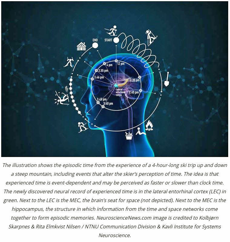 Figure 8 Efference (motor command) copy: Notice that the blue motor command bifurcates and sends a branch of the command to the back of the brain (labeled anterior cerebellum) where it is matched to what actually happened. This signal is then combined with the visual and vestibular to update
Is there any precedent in the animal kingdom for this motor copy thing? Yes, let us look at an ant in the African desert.4 As we shall see below it has a number of navigational possibilities but let us look first at how its tiny brain is able to keep track of his motor system. In one series of experiments ants were allowed to forage for food; but once they found their food they were subjected to a surgical procedure. Yes, this is going to sound weird but, heck, they are ants with a short life span anyway and as far as I know no ant was materially harmed in this experiment. So, before they were allowed to return to their nest with their food there were three groups whose legs were operated upon. In two groups they partially amputated the legs producing stumps (I and II) and in the third group they attached stilts. There was a control group as well. Lo and behold, the groups with the stumps undershot the nest and the group on stilts overshot the nest. (Figure 9)
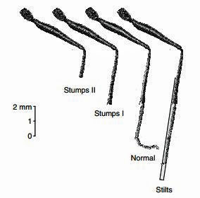 Figure 9: Stumps and Stilts
These 3 systems visual, vestibular, and motor copy allow us to do path integration when there are no external cues such as might occur anywhere including of course, on the water. In Figure 10 there is an unoperated ant in the African desert. Yes, she is small and no, she can’t appreciate hip hop, but she is probably a better natural navigator than you are!
There are few landmarks and the initial outbound foraging route is full of twists and turns as she looks for food. However, after she finds food, the return route based on path integration is relatively direct. Despite the twists and turns of the outbound foraging journey its little brain has kept track of the path and by the magic of path integration the ant can return home directly.
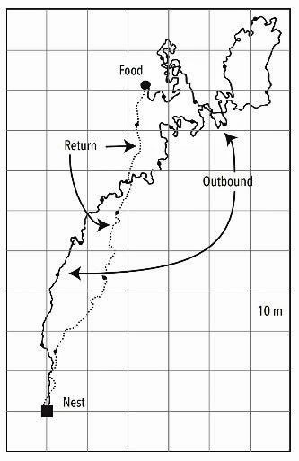 Figure 10: Outbound and Return
How do we know that her brain kept track of her movements and came up with a return vector? If you then displace the ant after it has obtained the food and is ready to return to the nest, it will take the route which was integrated and preplanned before the displacement. (Figure 11)
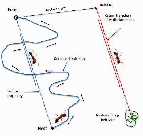 Figure 11: Outbound, return, and release after displacement5
I don’t want to give up on the desert ant quite yet because it has a great deal to tell us about how we should “train” our DR system. After the ant comes up from his nest (Figure 12) he spends 2-3 days walking around learning the position of his nest. During these learning walks he will periodically pirouette around and face his nest, encoding the nest position. (Figure 13). It will then forage for a week all the while observing the landmarks and the position of the sun. Once it finds its food it will return directly to the nest.
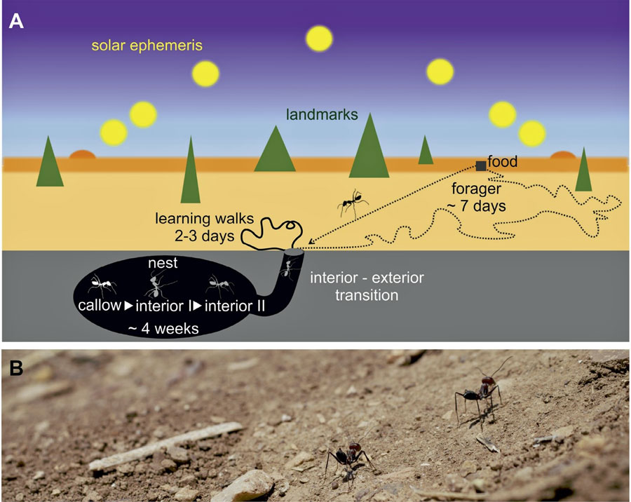 Figure 12: Ant foraging in the desert for food6
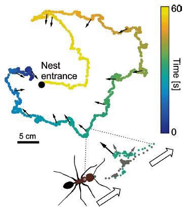 Figure 13: Ant on “learning walks”. The ant starts out waking the blue portion of the trail and periodically pirouettes to look at the nest and calibrate its internal compass. Once its compass is set it no longer needs to calibrate (Yellow portion)
How good is human path integration? It varies but in general, naïve subjects are not particularly good. Yes, we can find our way in the dark to the bathroom and avoid making a mess, but if given a course to walk with only a couple of turns most of us will miss the target. Some of us are better than others and with practice we can definitely improve. But we need to pay attention. The Polynesian boys (yes, there were only boys) had a coach with them for many years and eventually they honed their DR skills.
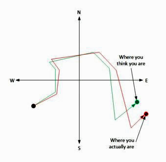 Figure 14: Dead Reckoning Task
If in general, DR / path integration in humans is poor – unless we actively work on it – and if dead reckoning has been replaced by GPS why consider this at all?
The United States Power Squadrons and the US Coast Guard Auxiliary / Boat US both teach DR as an essential tool for understanding navigation and as a backup for those inevitable times when electronic navigation fails. But in addition, by practicing formal nautical DR (Figure 15) you can begin to better appreciate your surroundings. On the water, for example, by examining the error in prediction between your calculated DR position and a navigation “fix” you can appreciate the local effect of wind and current in the area you are boating. But you can practice informal DR but simply paying attention to your body’s internal compass, and by comparing your internal speedometer versus the boat’s speed over the water. That is why that old salt whose been over the same area for hundreds of trips usually gets back to port in the densest of fogs. That is also how Professor Creamer made it around the world! The new term for that is “neuroplasticity,” the older term is “experience.”
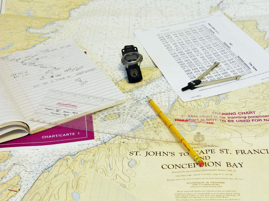 Figure 15: Nautical DR tools
Next: Navigation - Part 2 >>>
1 One of the earliest was Pytheas the Greek, a geographer and astronomer who travelled from the Mediterranean through the straits of Gibraltar to England, Western Europe, and points north to the edge of the Arctic Circle in approximately 325BC. He was the first to describe the midnight sun and polar ice.
2 Margalit Fox August 17, 2020 New York Times “Marvin Creamer, a Mariner Who Sailed Like the Ancients, Dies at 104.”
3 Jennifer Groh, Making Space: How the Brain Knows Where Things Are, 2014
4 Wittlinger M, et al, The desert ant odometer, J Exper. Biology 210, 198-207, 2007
5 Srinivasan, J Comp Physiol A 201:533-546, 2015
6 Grob et al Neuroforum https://doi.org/10.1515/nf-2018-0011 (same for figure 13)
Recent Articles
-
Beneteau Oceanis 473 Review: Specs, Performance & Cruising Guide
Feb 20, 26 04:49 AM
An in-depth review of the Beneteau Oceanis 473. Discover technical specifications, design ratios, and why this Groupe Finot design remains a top offshore cruising choice. -
Luders 36 Review: Specs, Performance Ratios & Cruising Guide
Feb 17, 26 06:20 PM
An in-depth expert review of the Luders 36 sailboat. Explore technical specifications, design ratios, and the offshore cruising capabilities of this classic Bill Luders design. -
Deck-stepped vs. Keel-stepped mast: An Offshore Engineering Guide
Feb 16, 26 07:59 AM
Comparing deck-stepped vs. keel-stepped mast systems. We analyze the propped cantilever effect, structural loads, and maintenance for offshore sailors.